A Historical Background on Groundwater Resource Development and Monitoring in Nepal
Department of Water Resources and Irrigation (DWRI) is a government organization, with a mandate to plan,
develop, maintain, operate, manage and monitor different modes of environmentally sustainable and socially
acceptable Irrigation Projects both surface and ground water or projects of water resources with
irrigation as major component, particularly larger in size. Also, DWRI works in the field of water induced
disaster management through water resources conservation and river training works. Additionally,
groundwater level monitoring of Terai region is now the responsibility of DWRI after dissolution of the
Ground Water Resources Development Board (GWRDB).
The exploration and identification of groundwater resources in Nepal began in 2024 BS. The Institution for
Groundwater Development has evolved over the years, with a growing emphasis on sustainable water
management. In 2024 BS, the Groundwater Survey Unit was established under the Department of Water
Resources Survey, marking the start of a structured approach to groundwater assessment. This initiative
progressed into the Groundwater Resources Survey Development Board in 2026 BS, further enhancing
coordination and research efforts. The development continued, leading to the establishment of the
Groundwater Resources Development Board in 2031 BS, focusing on comprehensive resource management. The
first revision of this board in 2033 BS underscored the need for adaptive strategies in response to
emerging challenges in groundwater sustainability, emphasizing the institution's commitment to fostering
effective and sustainable groundwater management practices. Initially, the Ground Water Resources
Development Board (GWRDB) focused on conducting extensive research on the development and exploration of
groundwater resources. The GWRDB conducted assessments in the Terai region to estimate the total amount of
groundwater reserves available in the area. As part of this initiative, the GWRDB collaborated with UNDP
and USAID to launch basic monitoring programs to observe the groundwater levels and their quality. Water
level observations began in 1987 BS as part of a study by Groundwater Development Consultants (GDC)
focused on developing irrigation strategies for the Terai region. The monitoring network primarily relied
on dug wells, and almost 60 to 70 wells were monitored in each Terai district. After UN project NEP/86/025
was implemented, systematic water level monitoring was initiated. The project entailed the drilling of 433
shallow monitoring wells, which were distributed across all Terai districts. The project involved drilling
between 20 and 25 shallow tube wells in each district, with the primary aim of manually collecting monthly
water level data. Overall, this monitoring network aimed to provide insightful data on groundwater
resources in the Terai region, which would be useful in developing sustainable irrigation strategies in
the area.
Nepal's Terai has an estimated 8,800 MCM of groundwater reserves, based on assessments carried out in the
1970s and 1980s, and abstraction of groundwater from these aquifers has steadily increased with irrigation
being the main water user. Electrification, promotion of solar pumps, increasing private investments in
diesel pump irrigation and growing industrial water use are progressively increasing the demand for
groundwater in Nepal's Terai and localized reports of groundwater depletion have started to surface.
Monitoring the water levels of the Terai's aquifers is thus critical to ensure that groundwater
development does not deplete the resource beyond sustainable limits. While the responsibilities of
groundwater management are currently spread across different governmental bodies, DWRI retains a mandate
for groundwater monitoring activities that are to be implemented through its branch offices.
Objective of Groundwater Dashboard
The objective of a groundwater dashboard is to provide a centralized, accessible platform for real-time data collection, storage, and analysis of groundwater resources. It aims to enhance decision-making by offering clear and organized visualization of groundwater levels and usage trends. The dashboard helps prevent over-extraction and ensures the long-term sustainability of aquifers. It integrates groundwater information with other relevant datasets, such as precipitation and land use, to offer a more comprehensive understanding of water resources. Additionally, the dashboard promotes transparency by making data easily accessible to government agencies, researchers, and local communities through user-friendly interfaces. It also ensures the accuracy and security of data through quality control measures, data validation, and secure access protocols. Overall, the dashboard aims to protect and preserve groundwater resources by supporting effective, data-driven decision-making.
Dashboard Development and Data Collection
The development of the groundwater dashboard is an ongoing process, with the first version designed to provide rapid support and real-time visualization for current data collection efforts. In the background, we are continuously enhancing the dashboard's features based on user feedback and operational experience. We encourage anyone to share their feedback, request new features, or contribute their data or web development expertise to improve the platform further. The monitoring wells used for data collection were initially selected in the 1980s and 1990s through UNDP and USAID-funded groundwater development programs, including large-scale hydrogeologic studies. To modernize data collection, we transitioned from manual methods to using Open Data Kit (ODK) on tablets and phones, allowing water levels to be measured and immediately entered a digital survey form. This data is then sent directly to the cloud for processing and visualization.
Geographical Setting and Hydro-geological Characteristics
Nepal's Terai belongs to the Northernmost section of the Indo-Gangetic Plains that stretch from the
foothills of the Himalayas to the Ganges Rivers in the South at around 100 masl. The aquifers thus belong
to the Indo-Gangetic Basin alluvial aquifer. General characteristics of the aquifers can, for example, be
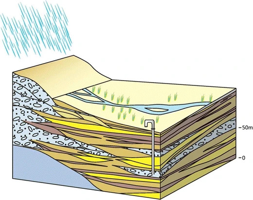
found in Bonsor et al. (2017). A typical cross
section of the Terai aquifer looks like the following (with yellow being coarser sand layers of good
aquifer material, Bonsor et al. 2017):

Nepal's Terai aquifers are comprised of alluvial and poorly sorted aquifer material. Several layers of
aquifer material are intersected by several layers semi-confining clay layers. Water levels for aquifers
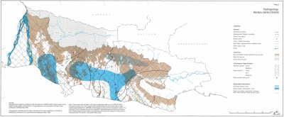
range from 0 to 10 mbgl with an average of 4.5 mbgl. The following map has been produced by the GWRDB
based on the water level measurements of the GWRDB/UNDP tubewells of 1993:


